Langley’s shift from rail-served farmland to high-density Willoughby and Latimer developments changed what shows up under the sieve stack. Glaciomarine silts, Sumas outwash sands, and Fort Langley floodplain clays all coexist within a few kilometres, and a single borehole log based on feel alone rarely captures the transition zones. We run the full sieve plus hydrometer curve because the Township’s geotechnical review often demands a laboratory particle-size distribution for stormwater infiltration compliance, seismic site class justification, and frost-protection design under NBCC Division B. The hydrometer side is non-negotiable when fines content crosses 12 percent, which happens regularly in the Aldergrove till and Nicomekl lowlands.
When fines content hovers near 12–15 percent, the hydrometer side of the curve makes the difference between site class C and D under NBCC.
Method and coverage
Regional considerations
Langley sits at roughly 49.10° N, 122.66° W, where winter groundwater recharge keeps near-surface silts saturated for months. Skipping the hydrometer portion leaves the fines curve flat below 75 μm, which leads to two common failures: undersized stormwater infiltration estimates and missed frost-susceptibility triggers under NBCC. The Township’s engineering department routinely flags grain-size reports that stop at the No. 200 sieve when the sample is silt-rich, because frost heave protection depth—often 450 mm or more—depends directly on silt-clay percentages. A sample that sieves 92 percent sand can still hold enough clay-size binder to slump in an open excavation after a week of January rain. The full curve also feeds the USCS classification that underpins seismic site response: a few extra percent clay can shift a site from liquefaction-prone to non-liquefiable under NCEER criteria.
Standards that apply
CSA + ASTM D422(2007)e2 – Standard Test Method for Particle-Size Analysis of Soils, ASTM D6913/D6913M-17 – Sieve Analysis of Fine and Coarse Soils, NBCC 2020 Division B – Frost protection and seismic site classification
Complementary services
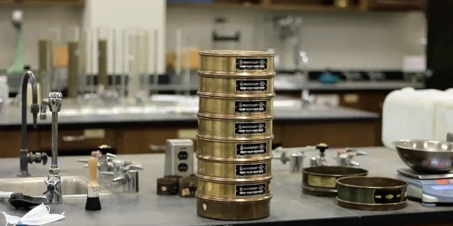
Full Sieve + Hydrometer Package
One combined report from coarse gravel down to clay colloids. Includes wash-through-No.200, oven-dry sieve stack, 24-hour hydrometer sedimentation with temperature correction, and USCS classification with Cu/Cc. Standard turnaround is three business days.
Wash-Sieve Only (Sand/Gravel Cut)
Suitable for clean granular borrow or concrete aggregate checks where the hydrometer is not required. Covers 75 mm to 75 μm with percent fines by wash loss. Often paired with Proctor or CBR for Township road-base acceptance.
Typical parameters
Top questions
How much does a combined sieve and hydrometer test cost in Langley?
A combined CSA + ASTM D422/D6913 analysis typically runs between CA$140 and CA$270 per sample, depending on whether it is a single point or part of a multi-depth borehole program. The final figure depends on gravel content and the number of sieve fractions requested.
Why does the Township of Langley require the hydrometer when the soil feels sandy?
Even sand that feels clean can carry 10–18 percent silt and clay, which controls both frost heave susceptibility and infiltration rate. The hydrometer quantifies that fraction below 75 μm so the Township can confirm the soil meets the drainage and frost-protection assumptions in the servicing plan.
How much sample do you need for a full grain-size curve?
For typical Langley silty sands we ask for at least 500 grams of oven-dried material. If the sample contains gravel larger than 19 mm, we prefer 3–5 kg to ensure the coarse fraction is representative. Shelby tube or split-spoon samples work well as long as they are sealed to preserve natural moisture.
What is the standard turnaround time for a grain-size report?
Standard turnaround is three business days from sample receipt. Faster 24-hour rush reports are available when the hydrometer sedimentation period can be shortened with a calibrated pipette method, though we recommend the full 24-hour reading for clay-rich Langley silts.